

Article-At-A-Glance
- Drones can reduce solar farm inspection times by up to 85%, making manual ground inspections increasingly obsolete.
- Thermal imaging technology allows drones to detect faulty solar panels, hot spots, and microcracks invisible to the naked eye.
- Solar-powered drones create a self-sustaining energy loop on farms, cutting electricity bills by 20–40% while extending flight times.
- Integrating drone data with farm management systems enables real-time crop monitoring, precision irrigation, and proactive maintenance — all from a single platform.
- Keep reading to find out exactly which drone types work best for solar farm inspections and whether small-scale farms can realistically afford this technology.
Drones and solar power are no longer separate technologies on the farm — they are becoming one integrated system that is reshaping how agricultural energy is managed from the ground up.
The pressure on farmers to produce more while spending less has never been higher. Solar farms attached to agricultural operations promise long-term energy savings, but only if they are maintained properly. A single faulty panel can cause energy losses that quietly drain profitability for months before anyone notices. That is where drones change everything. Growing Solar Mist has been at the forefront of documenting how this technology is giving farmers a real operational edge.
Drones Are Changing Solar Farm Management Right Now
Traditional solar farm inspections are slow, labor-intensive, and frankly dangerous in large installations. Ground crews spend days walking rows of panels, using handheld thermal guns and visual checks that miss more than they catch. The result is delayed fault detection, increased downtime, and higher operating costs.
Drones flip this model entirely. A drone equipped with a thermal infrared camera can survey hundreds of panels in a single flight, generating data that would take a ground team days to collect. The shift is not gradual — farms that adopt drone inspection programs report immediate, measurable improvements in fault detection rates and inspection turnaround times.
What makes this transformation particularly significant for farmers is the compounding benefit. Faster inspections mean faster repairs. Faster repairs mean higher energy output. Higher energy output means lower electricity costs and better return on the solar investment. The technology pays for itself — and then some.

How Drones Inspect Solar Panels Faster Than Any Ground Crew
Speed is only part of the story. The real advantage drones offer is the quality and consistency of data they collect at that speed. A ground inspector has physical limitations — fatigue, restricted sightlines, and inconsistent technique. A drone does not.
Thermal Imaging Finds Faults Invisible to the Human Eye
Modern inspection drones are fitted with thermal infrared sensors that detect temperature anomalies across panel surfaces. When a solar cell degrades, develops a microcrack, or becomes partially shaded by soiling, it generates excess heat — a thermal signature that shows up clearly on infrared imagery even when the panel looks perfectly fine to the naked eye.
This matters enormously in practice. Hot spots on solar panels are one of the leading causes of long-term efficiency loss and, in severe cases, fire risk. Detecting them early — before visible damage occurs — allows farm operators to schedule targeted maintenance rather than reactive emergency repairs. The DJI Zenmuse XT2 thermal camera, commonly mounted on the DJI Matrice 300 RTK drone, is one of the industry-standard setups for this type of solar panel inspection work, offering dual thermal and visual imaging in a single flight pass.
Drone Surveys Cut Inspection Time by Up to 85%
The 85% reduction in inspection time is not a theoretical estimate — it reflects documented operational outcomes from solar farm operators who have replaced manual inspection protocols with drone-based systems. A large-scale solar array that previously required a five-day ground inspection can now be fully assessed in less than a day.
This efficiency gain has a direct financial impact. Fewer labor hours, lower inspection costs, and reduced downtime all contribute to a stronger bottom line. For agricultural solar farms operating on tighter margins than utility-scale installations, this efficiency advantage is not just convenient — it is critical.
AI-Powered Analysis Turns Aerial Data into Actionable Fixes
Capturing thermal imagery is only half the process. The raw data collected by drones needs to be analyzed quickly and accurately to be useful. This is where artificial intelligence steps in. AI-powered software platforms — such as Raptor Maps and similar solar analytics tools — process drone-captured imagery automatically, flagging anomalies, categorizing fault types, and prioritizing repairs by severity.
Instead of an engineer manually reviewing hundreds of thermal images, the AI delivers a structured fault report within hours of the drone flight. Each flagged panel is geotagged, so maintenance crews can go directly to the problem location without searching. This closes the loop between data collection and action in a way that manual inspection simply cannot match. For more information on solar panel types that can benefit from this technology, check out this comparison of bifacial vs. thin-film solar panels.
Solar Power and Drones: A Self-Sustaining Energy Loop
One of the most compelling developments in agricultural technology is not just drones inspecting solar panels — it is solar panels powering the drones themselves. This closed-loop energy relationship creates operational efficiencies that compound over time, reducing dependence on grid electricity and fossil fuels simultaneously.
How Solar Panels Power Drone Operations On-Farm
On-farm solar installations can be configured to include dedicated drone charging stations powered entirely by the solar array. This means the energy cost of running drone inspection and monitoring programs effectively drops to near zero once the solar infrastructure is in place. Farmers are using the same energy asset they are trying to protect to fund the protection itself.
Beyond inspections, solar-powered charging stations allow drones to operate on continuous rotation schedules — fly, recharge, fly again — without relying on grid power or diesel generators. This is particularly valuable for remote agricultural properties where grid access is limited or expensive.
Extended Flight Times With Solar-Integrated Drone Designs
Solar cell integration directly into drone airframes is an emerging hardware development that addresses one of the biggest limitations of commercial drones: battery life. Standard agricultural drones like the DJI Agras T40 carry enough battery for approximately 22 minutes of flight per charge under full load. Solar-integrated designs extend this by harvesting ambient light during flight, feeding supplemental power back into the battery system.
While fully solar-sustained drone flight remains in development for heavier agricultural models, lighter survey drones are already seeing flight time extensions of 20–30% through integrated flexible photovoltaic panels on wing surfaces. For large solar farm inspections covering hundreds of acres, that additional flight time translates directly into fewer battery swaps, fewer interruptions, and lower labor overhead per inspection cycle.

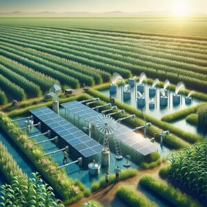
“Drones Enhance Solar Irrigation Systems …” from growingsolarmist.com and used with no modifications.
Precision Crop and Water Management From Above
Drone utility on solar-integrated farms extends well beyond panel inspections. The same aircraft used to monitor energy infrastructure can be redeployed over crops, delivering high-resolution multispectral data that drives smarter irrigation and fertilization decisions. This dual-use capability dramatically improves the return on investment for any drone program.
Moisture Mapping Stops Water Waste Before It Starts
Drones equipped with multispectral sensors — such as the MicaSense RedEdge-MX — capture data across multiple light wavelengths simultaneously, including near-infrared bands that reveal soil moisture levels invisible to standard cameras. The resulting moisture maps show exactly which zones of a field are adequately irrigated, which are stressed, and which are being overwatered. For those interested in optimizing agricultural technology, bifacial solar panels can also play a significant role in enhancing farm efficiency.
Overwatering is a silent profitability killer on many farms. It wastes water, leaches nutrients from soil, and can promote root disease. Multispectral drone surveys conducted before irrigation cycles allow operators to apply water only where the data shows it is needed, with some farms reporting water use reductions of up to 30% after implementing drone-guided irrigation protocols.
Real-Time Crop Health Data Feeds Solar-Powered Irrigation Systems
When drone data is integrated with automated solar-powered irrigation systems, the workflow becomes genuinely intelligent. Drones survey crop health, software analyzes the multispectral imagery, and irrigation controllers receive zone-specific watering instructions — all without manual input. The solar array powers the irrigation pumps. The drone data tells those pumps exactly when and where to run.
This integration is already operational on progressive farms using platforms like the Trimble Ag Software suite combined with DJI drone data outputs. The result is a closed-loop precision agriculture system where energy generation, crop monitoring, and water management operate as a single coordinated network rather than three separate manual processes.
Identifying Poor Drainage Zones With Aerial Surveys
Standing water and poor drainage are chronic problems on many agricultural properties. Left unaddressed, waterlogged zones reduce crop yields, accelerate soil compaction, and create conditions for fungal disease. Identifying these zones from the ground requires extensive manual scouting — time and labor that most farm operations cannot consistently spare.
Drone surveys using RGB high-resolution cameras and thermal sensors can map drainage patterns across an entire property after a rainfall event in a single flight. The aerial perspective reveals flow patterns and pooling zones that are completely invisible at ground level. Armed with this data, farm managers can make targeted drainage improvement investments rather than guessing where the problems originate.
The Real Cost of Drone Technology for Farmers
Cost is always the central question when evaluating new farm technology, and drone systems are no exception. The honest answer is that upfront investment is real — but so are the documented long-term savings, and the math increasingly favors adoption even for mid-scale operations. For more insights on how drone technology is paving the way for a solar-powered future, visit Sager Drone’s blog.
Upfront Investment vs. Long-Term Electricity Savings of 20–40%
A professional-grade agricultural drone setup — including the aircraft, thermal and multispectral sensors, and data analysis software — typically ranges from $10,000 to $30,000 depending on configuration. That is not a trivial expense. However, farms that integrate drone management with their solar installations report electricity bill reductions between 20% and 40%, driven by faster fault detection, optimized panel performance, and reduced energy waste from irrigation inefficiencies.
Real-World Cost Comparison: A mid-scale farm spending $4,000 per month on electricity that achieves a 30% reduction through drone-optimized solar management saves $1,200 per month — recovering a $15,000 drone investment in approximately 12 months, with pure savings continuing from year two onward.
Reduced Labor Costs From Automated Inspections
Manual solar panel inspections on a large agricultural installation can require two to four technicians working for three to five days per inspection cycle. At standard agricultural labor rates, a single inspection event can cost $3,000 to $8,000 depending on farm size and local wages. Drone inspections of equivalent scope typically cost a fraction of that — particularly when the drone is owner-operated rather than contracted out. For those considering upgrades, monocrystalline vs polycrystalline solar panels offer various benefits that can further optimize agricultural efficiency.
The labor saving compounds when inspection frequency increases. Because drone surveys are so much faster and cheaper, farms can conduct inspections quarterly or even monthly rather than annually. More frequent inspections mean faults are caught earlier, repair costs stay lower, and energy output remains consistently optimized throughout the year rather than recovering only after an annual check reveals months of hidden degradation.

Where Drone and Solar Technology in Farming Is Headed
The trajectory is clear: drones and solar technology are converging into a single farm management ecosystem rather than remaining parallel tools.
The next wave of development is focused on autonomous drone systems that operate on pre-programmed schedules without pilot input — launching from solar-powered docking stations, completing inspection or monitoring routes, and uploading data automatically before returning to recharge.
Companies like Percepto and Skydio are already deploying autonomous drone-in-a-box systems for industrial infrastructure monitoring, and agricultural adaptations are following closely behind. Within the next five years, it is realistic to expect fully automated drone patrol systems on larger agricultural solar installations — systems that monitor both crop health and panel performance daily, without a single manual flight operation.
Regulatory frameworks are also evolving to support this shift. The FAA’s Beyond Visual Line of Sight (BVLOS) rulemaking in the United States is progressively opening airspace for autonomous commercial drone operations, removing one of the last significant barriers to large-scale agricultural drone automation. For farmers investing in solar infrastructure today, building drone compatibility into that investment is not forward-thinking — it is simply practical planning.
Frequently Asked Questions
Farmers exploring drone and solar integration consistently land on the same practical questions. Here are the most important ones answered directly, without the technical jargon.
How Often Should Solar Panels on a Farm Be Inspected by Drone?
For most agricultural solar installations, a quarterly drone inspection schedule strikes the right balance between thoroughness and cost. Quarterly inspections ensure that seasonal soiling buildup, storm damage, and gradual cell degradation are caught within a three-month window — before efficiency losses become significant.
High-value or larger installations benefit from monthly thermal surveys, particularly during peak summer months when heat-related hot spot development accelerates. The low per-inspection cost of drone surveys makes this frequency economically viable in a way that manual inspection schedules never were.
At minimum, every agricultural solar installation should be surveyed by drone at least twice per year — once before peak energy demand season and once after. Waiting for visible damage or a noticeable drop in energy output to trigger an inspection is the costliest approach, as degradation is often well advanced by the time it becomes apparent through output metrics alone.
Can Small-Scale Farms Afford Drone Technology?
Small-scale farms have more options than most owners realize. Rather than purchasing a full drone system outright, many smaller operations contract specialized agricultural drone service providers for seasonal inspections at a fraction of ownership costs. A single professional drone thermal inspection of a small solar installation typically runs between $500 and $2,000 depending on array size and provider — affordable even on tight budgets when scheduled annually or biannually.
What Type of Drone Is Best for Solar Farm Inspections?
The best drone for solar farm inspections depends on the size of the installation and the specific data needed. For most agricultural solar farms, a mid-size multirotor drone with an integrated thermal camera is the practical standard. The DJI Matrice 300 RTK paired with the Zenmuse XT2 thermal payload is widely considered the benchmark setup — combining long flight time (55 minutes), high payload capacity, and dual thermal-visual imaging in one aircraft. For more insights on how drones are transforming solar farm efficiency, explore our detailed guide.
For smaller installations or farms with tighter budgets, the DJI Mavic 3 Thermal offers a capable and significantly more affordable entry point, with a built-in 640×512 thermal sensor and a 45-minute flight time that covers most small-to-mid scale solar arrays in a single battery cycle. Fixed-wing drones like the senseFly eBee X are better suited to very large utility-scale solar farms where coverage area exceeds what a multirotor can efficiently survey in a single session.
Do Solar-Powered Drones Work in Cloudy or Low-Light Conditions?
|
Condition |
Solar Charging Impact |
Inspection Capability |
|---|---|---|
|
Full Sun |
Maximum charging rate, extended flight |
Optimal thermal contrast for fault detection |
|
Partial Cloud Cover |
Reduced but functional solar input |
Good thermal imaging, minor contrast reduction |
|
Heavy Overcast |
Minimal solar supplementation |
Thermal imaging still functional, battery-dependent |
|
Dawn / Dusk |
Near-zero solar supplementation |
Strong thermal contrast — often ideal for inspections |
Interestingly, dawn and dusk are actually preferred inspection windows for thermal solar surveys. During these transitional light periods, panels that have been absorbing heat during the day retain warmth while the ambient air temperature drops, creating sharper thermal contrast that makes fault signatures easier to identify in the imagery. Full midday sun, while ideal for solar charging, can reduce thermal contrast enough to make subtle hot spots harder to distinguish.
For solar-powered drone charging stations, cloudy periods are managed through battery buffer systems — the solar array charges a battery bank continuously, and that stored energy powers the drone charging stations regardless of real-time sun conditions. A properly sized battery buffer can sustain drone operations through two to three consecutive cloudy days without any grid power input.
How Does Drone Data Integrate With Existing Farm Management Systems?
Most modern agricultural drone platforms output data in standardized formats — orthomosaic maps, georeferenced thermal images, and structured fault reports — that are designed to feed directly into farm management software. Integration with platforms like John Deere Operations Center, Trimble Ag Software, and Climate FieldView is increasingly plug-and-play through API connections and compatible file formats.
For solar-specific management, drone data platforms like Raptor Maps and Greenbyte provide dedicated solar asset management dashboards where drone inspection results, historical performance data, and maintenance records are consolidated in a single interface. This gives farm managers a complete picture of solar system health alongside crop performance metrics without toggling between disconnected software systems.
The practical setup process typically involves exporting drone flight data to the analysis platform immediately post-flight, reviewing the generated fault or crop health report within 24 hours, and uploading prioritized action items into the farm’s maintenance scheduling system. Most farms operationalizing this workflow for the first time report that the integration setup takes one to two weeks of configuration before it runs smoothly. For farms interested in enhancing their energy efficiency, exploring solar panel options can be beneficial.

Leave a Reply